 Multiple Areas of Interest
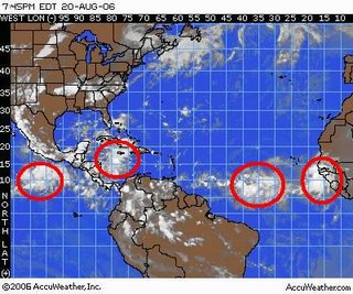
(Jacksonville, FL) Convection over several areas of the Atlantic Basin have flared up through the day. The main reasons for this are the decrease in both the shear and dry air.
One area of interest is in the Central Caribbean. Shear is strong at this time which is keeping development in-check. There is generally concern for this system once it enters the Northwest Caribbean/Southeast Gulf. Models continue to show development of this system.
There are a couple of strong waves in the Atlantic. One in the Central Atlantic some 500-600 miles east of the Lesser Antilles & a second closer to the coast of Africa. Forecast models have been consistently picking up on & developing tropical cyclones in the Central Atlantic. Dry air, shear, and African dust are all on the decrease making these areas some of the most favorable in the Atlantic.
Comments