Tropical Storm Maria Forms

Maria Official Forecast
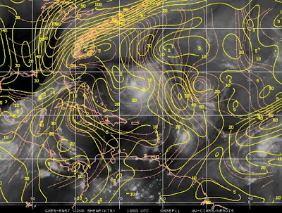
Tropical storm Maria becomes the 12th named storm this season and likely the third hurricane. Maria's intensification over the next several days will be gradual and not rapid. There are 2 hindering factors as she continues to move to the west and west-north-west. First off, shear looks to be moderate in nature over the next couple of days. A second hindering factor is simply how fast the storm is moving. Maria continues to plow westward at nearly 20 mph. The combination of shear and its fast movement serve as a hindrance and will make it tough for the storm, in the SHORT TERM, to become a hurricane.   

Shear is steady ahead of Maria
This storm will likely become a hurricane during the early part of the weekend, once conditions become more favorable. One thing this storm does have going for it is that it is in a moist, tropical envelope. And the fact it is not dealing with dry air is a rarity this season. This conducive envelope will allow the storm to strengthen into a hurricane as it threatens the northern Leeward Islands. As I see it now, the Leeward Islands will likely feel the force of category 2 hurricane. 

Moist Environment Surrounds Maria
As for long term threats, it appears that that will depend on exactly how fast the storm moves. A faster moving storm will likely recurve and miss the United States. My personal forecast calls for direct effects from the storm to be felt in Central/South Florida and the Carolinas. A very similar path to Irene is a plausible forecast, at this point in the game. 

My Personal Forecast
Hurricane Irene's track: August 2011

Comments