All in all, Christmas Eve Day will be a near average day. The low temperature will start cooler than average but will quickly warm up to average and slightly beyond. Historically, the day the before Christmas tends to be on the normal side of the spectrum.
Forecast High Temperature: 66
Forecast Low Temperature: 42
Average High Temperature: 65
Average Low Temperature: 43
Record High Temperature: 84 (in 1956)
Record Low Temperature: 24 (in 1989)

The majority of the country will have near average temperatures on the day of Christmas Eve. The coldest part of the country will be the Upper Midwest, as the newest storm will be affecting this region. The warmest weather will be in South Florida, with temperatures nearing 80 degrees.
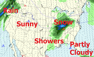
Partly cloudy skies will dominate the day, here on the First Coast. There is only a 20% chance of rain. the best chance of rain occurring will be after 10 PM. As for the rest of the country, the greatest chance of adverse weather conditions exists in the Midwest, where the Ohio Valley could receive several inches of snow. Showers will exist from Tennessee Valley to the Gulf Coast. Both the Northeast and Mountain/Central regions look drive. There will be plenty of rain to be found in the Pacific Northwest, in advance of the newest storm system to enter the country.
Forecast High Temperature: 66
Forecast Low Temperature: 42
Average High Temperature: 65
Average Low Temperature: 43
Record High Temperature: 84 (in 1956)
Record Low Temperature: 24 (in 1989)

The majority of the country will have near average temperatures on the day of Christmas Eve. The coldest part of the country will be the Upper Midwest, as the newest storm will be affecting this region. The warmest weather will be in South Florida, with temperatures nearing 80 degrees.
Partly cloudy skies will dominate the day, here on the First Coast. There is only a 20% chance of rain. the best chance of rain occurring will be after 10 PM. As for the rest of the country, the greatest chance of adverse weather conditions exists in the Midwest, where the Ohio Valley could receive several inches of snow. Showers will exist from Tennessee Valley to the Gulf Coast. Both the Northeast and Mountain/Central regions look drive. There will be plenty of rain to be found in the Pacific Northwest, in advance of the newest storm system to enter the country.

Comments