June marks the first month of the hurricane season. Since water temperatures aren't at their highest levels, nor, are shear values at their lowest, development of an tropical system will be slow to occur. June only averages about 0.5 named storms. This means that only about every other June actually produces a named storm.
> Current analysis shows nothing of organization or anything that will develop during the next
3-4 weeks. This means that all most the entire month of June will be free of tropical cyclones.
 |
| Current IR-AVN of the Atlantic Basin |
> Surprisingly, African Dust does not seem to be the problem. Dust is usually stronger in intensity, during this time of year. Dust usually obliterates the potential for clouds to form and, therefore, rain and development to occur.
 |
| Current Sahara Dust |
> What does seem to be a limiting factor are shear values. They are quite impressive for this time of the year. The strongest values are right over the climatological hot spots. With such high shear values (50-60 kts), thunderstorms have no chance at organization.
 |
| Current Shear Level Values |
> Velocity anomalies indicated more of a sinking motion over the Atlantic Basin. They will tend to be on the downward trend for at least the next couple of weeks.
 |
| Upward Motion Velocities |
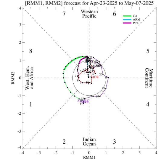
> Finally, as long as the current MJO is not in octane 8 or 1, chances are against there being any tropical storm activity in the Caribbean, Gulf, or Atlantic. Probabilities will be close to nil for the next 45 days, until the MJO reaches the latter parts of octane 7.

Comments
камелот воронеж знакомства