There is a lot of wishcasting going on right concerning the future of Irene. Once again Florida will escape most, if not all of the affects of the hurricane. The only result of the storm Florida will see is some increased surf activity. There remains a decent sized trough that will pull the storm to the north and northeast. This trough is being forecasted by all of the best computer models.
The turning mechanism for the storm is almost in place, and the storm may already be seeing the affects of this. See the "U" shaped weather feature over Ohio, Pennslyvania, and New York? That is the weather feature of importance; its the trough.
The stronger the storm is, the more likely it will feel the trough and get pulled into it. And the higher up you go in the atmoshpere the more pronounced the weakness is. Troughiness has really been part of this summer's pattern along the East Coast. As a result of the synoptics computer models look like this:
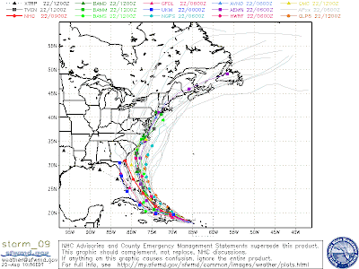
The one I have been following throughout this storm has been the Navy's NOGAPS. On this map, it does not even show that the storm is a threat to the Outer Banks, of NC. As a reminder, here is was my first forecast: (My second forecast for the storm has even shifted further east)
At Irene's closest approach to the First Coast, the storm could be around 350 miles offshore. Again, this would provide nothing but sunshine for the First Coast and maybe the longest streak of 90 degree temperatures in Jacksonville's history.
I guess the doom and gloom sayers have to wait to the next storm. The latest on the real threat to the First Coast (The Drought) later on.
And if you don't believe in what my forecast says hop on over to see what meteorologist Mike Buresh says about the tropics. He has a great write up on the storm. (Preview: He is not crying wolf)
http://www.actionnewsjax.com/content/talkingtropics/story/Hispaniola-to-Be-Skirted-by-Irene/1F58fgkvoUSE96NINclDzg.cspx
 |
| GFS 500 mb Forecast Model |
 |
| Trough Already In View |
The stronger the storm is, the more likely it will feel the trough and get pulled into it. And the higher up you go in the atmoshpere the more pronounced the weakness is. Troughiness has really been part of this summer's pattern along the East Coast. As a result of the synoptics computer models look like this:

The one I have been following throughout this storm has been the Navy's NOGAPS. On this map, it does not even show that the storm is a threat to the Outer Banks, of NC. As a reminder, here is was my first forecast: (My second forecast for the storm has even shifted further east)
 |
| My Personal First Forecast |
 |
| Second Call |
Irene's Effects for First Coast:
-Rough seas and surf through weekend (this includes rip currents)
-Breezy conditions (but less than 30 mph)
-Little to NO rain
-Warm Temperatures (At least 92 degrees through week and weekend)
I guess the doom and gloom sayers have to wait to the next storm. The latest on the real threat to the First Coast (The Drought) later on.
And if you don't believe in what my forecast says hop on over to see what meteorologist Mike Buresh says about the tropics. He has a great write up on the storm. (Preview: He is not crying wolf)
http://www.actionnewsjax.com/content/talkingtropics/story/Hispaniola-to-Be-Skirted-by-Irene/1F58fgkvoUSE96NINclDzg.cspx
Quick Update:
Newest GFS Model run in. The storm may even pass Jacksonville to east around 500 miles.
Newest GFS Model run in. The storm may even pass Jacksonville to east around 500 miles.
Comments