
Even though it might be cold now, a large-scale pattern change is on the way on the way for spring. This should help bump temperatures above average for the months of March, April & May. Accompanied by the warmth will be drier than average conditions for portions of the Southeast. An indicator of the state of the cold air is the North Atlantic Oscillation (NAO) index.
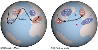
The NAO is based on the surface pressure difference between the Subtropical High
and the Subpolar Low. When the NAO turns negative, it usually means cold
air is impacting the eastern third of the nation. During times of positive NAO,
the opposite tends to be true and the East Coast experiences a warm-up.

The NAO was in negative territory during the beginning part of February and was expected to turn positive towards the end of the month. March is the first month when our average high reaches the 70s and that increases into the 80s by mid-May. Based on early forecasts, expect Northeast Florida to reach 80s several days in March and approach the 90 degree mark by May.


Comments