
The first, significant tropical disturbance of the season that developed from an African wave, impacted the First Coast as a tropical storm on July 7th. Elsa dumped several inches of rain, produced winds of 40 – 50 mph and was responsible for the formation of waterspouts and tornadoes.


The system strengthened into a tropical depression in the central Atlantic on July 1st and quickly moved across the basin. In fact, its forward speed was around 30 mph, which is rare for a tropical cyclone to keep together, while having that fast of a forward speed. Despite not having the best development scheme, Elsa become the season’s first hurricane in the Caribbean. Forecast models had difficulty maintaining and keeping a solid forecast with the storm. Despite the lack of model continuity, the National Hurricane Center outperformed on intensity forecast and the system’s track.
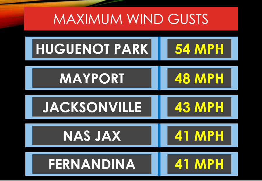
The center of Tropical Storm Elsa got within 90 miles of Jacksonville. The area starting feeling significant effects several hours after the storm made landfall near Steinhatchee, FL. The storm officially made landfall with sustained winds of 65 mph and a pressure of 999 mb. In the Jacksonville area, our highest wind gust was around 50 mph, with many locations reporting gusts around 40 mph.

The two big impacts to come out of Elsa where the rains and the severe weather. The area saw between 1” to 6” of rain, which led to isolated flooding in the common, flood-prone areas. Elsa produced several waterspouts and at least 3 local tornadoes. Damage from these tornadoes was reported in Lake City, the Philips Highway area of Jacksonville and at Kings Bay in Southeast Georgia. The inclement weather is blamed for damaging a tree, which fell on a vehicle, and killed the driver on U.S. 17 in Ortega. And at least 10 people were injured during the sizable tornado in Southeast Georgia.

Comments